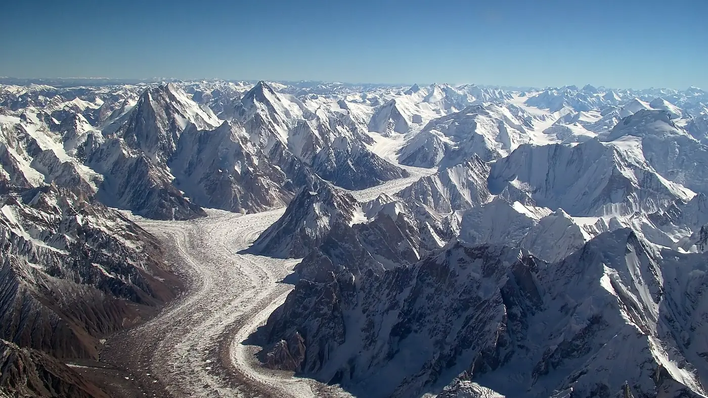
Concordia is the glacier junction in Pakistan's Karakoram where the Baltoro glacier meets the Godwin-Austen glacier, at about 4,600 to 4,700 metres in Baltistan. From its camp you see K2, Broad Peak, the Gasherbrums and Chogolisa without turning more than your head. There is no road: reaching it takes six to eight days on foot from Askole, the last village, which is itself a day's jeep ride from Skardu.
This guide explains where Concordia sits, what you can see from it and in which direction, how long the walk in takes, and what a night there is like. The stage-by-stage route belongs to our K2 base camp trek guide; here the focus is the place itself.
| At a glance | |
|---|---|
| What it is | The meeting point of the Baltoro and Godwin-Austen glaciers |
| Altitude | About 4,600 to 4,700 m; published figures vary |
| Nearest village | Askole, 3,050 m, the roadhead in the Braldu valley |
| Distance from Askole | Roughly 80 km on foot, one way |
| Days to reach it | 6 to 8 from Askole, including a rest day |
| Peaks in view | K2, Broad Peak, Gasherbrum IV and II, Chogolisa, Mitre Peak |
| Season | July and August; June and September possible |
| Park | Central Karakoram National Park, restricted trekking zone |
Where is Concordia?
Concordia lies in the heart of the Central Karakoram, close to the border with China. It is not a settlement but a wide, level stretch of rubble-covered ice where several glaciers come together.
The Baltoro flows west from here, down to its snout near Paiju and the Braldu river. The Godwin-Austen glacier comes in from the north, from the foot of K2. To the south-east, the Upper Baltoro climbs towards Baltoro Kangri and the Conway Saddle, and a side arm, the Vigne glacier, leads south to the Gondogoro La and the Hushe valley.
Every route in the upper Baltoro passes through it: north to the K2 and Broad Peak base camps, east towards the Gasherbrums, and south over the pass to Hushe. That makes it the natural place to camp, rest and wait for weather.
The name was borrowed by early European climbers from the Konkordiaplatz, a similar glacier junction on the Aletsch glacier in the Swiss Alps.
Why is it called the Throne Room of the Mountain Gods?
The phrase comes from In the Throne Room of the Mountain Gods, the American photographer and climber Galen Rowell's 1977 book about the 1975 American expedition to K2. Its large-format colour photographs made the upper Baltoro famous among climbers and trekkers abroad, and the title stuck to Concordia.
It is an apt description. Four of the world's fourteen 8,000-metre peaks stand within a day's walk: K2, Broad Peak, Gasherbrum I and Gasherbrum II. Few campsites anywhere put so many of the highest mountains so close.
Which peaks can you see from Concordia?
On a clear day, these are the mountains most trekkers pick out:
| Peak | Height | Where to look |
|---|---|---|
| K2 | 8,611 m | North, filling the head of the Godwin-Austen glacier |
| Broad Peak | 8,051 m | North-east, the long summit ridge beside K2 |
| Gasherbrum IV | 7,925 m | East, its huge west face straight across the ice |
| Gasherbrum II | 8,035 m | East, peeking out to the right of Gasherbrum IV |
| Baltoro Kangri | 7,312 m | South-east, at the head of the Upper Baltoro |
| Chogolisa | 7,665 m | South-east, a broad snow summit |
| Mitre Peak | 6,010 m | South, a sharp point right above camp |
K2
K2 is the reason most people come. It stays hidden behind nearer ridges for most of the walk up the Baltoro and comes into full view only as you reach Concordia. From camp it stands alone at the end of the Godwin-Austen glacier as a near-perfect pyramid. The light on it at sunset, and again at first light, is what most trekkers remember.
Broad Peak and the Gasherbrums
Broad Peak rises beside K2, its long, flat-topped summit ridge explaining the name. Across the ice to the east, the west face of Gasherbrum IV is the wall you see most of. It is often called the Shining Wall, though the Balti name Gasherbrum is usually explained as "beautiful mountain". Gasherbrum II peeks out to the right of it.
Gasherbrum I, at 8,080 metres, is the one 8,000-metre peak nearby that you will not really see. It stays tucked behind the other Gasherbrums for most of the Baltoro, which is why the climber Martin Conway called it Hidden Peak in 1892.
Chogolisa and the south side
Looking up the Upper Baltoro, Chogolisa's broad white summit and Baltoro Kangri close the valley. Conway named one of Chogolisa's summits Bride Peak. Closer in, Mitre Peak rises like a bishop's hat above the camp, with the route to the Gondogoro La behind it.
Our list of the highest peaks in Gilgit-Baltistan sets these mountains alongside the ones you can see from the road.
How long does it take to reach Concordia?
Concordia is roughly 80 km on foot from Askole. For a normal group, that is:
- Skardu to Askole: a day by jeep, about six hours when the track is clear.
- Askole to Paiju: two days along the Braldu river, then a rest day at Paiju, which nearly every group takes.
- Paiju to Concordia: three or four days up the glacier, via Urdukas and Goro II, some groups adding a night at Khoburtse or a second rest day at Urdukas.
That makes six to eight days from Askole, or seven to nine from Skardu. Coming back the same way is quicker, usually four or five days to Askole, because everyone is acclimatised and the route loses height.
Almost every Concordia itinerary includes the day up to K2 base camp, so with spare days for weather the full trip usually comes to 15 to 17 days from Skardu. Some operators sell private helicopter or light-aircraft flights over the upper Baltoro from Skardu, but to stand at Concordia you have to walk.
In recent seasons the jeep track has been pushed beyond Askole towards Jhola, which can save a day each way. Ask your operator whether it is open in your year.
What is it like to camp at Concordia?
Concordia is a camp on the glacier itself: tents pitched on stones and gravel over ice that glaciologists have measured at more than 800 metres deep.
- Cold. Days can be warm in the sun, but nights fall below freezing even in July, and the higher camps nearby drop to around minus 10°C. You need a sleeping bag rated well below zero and a thick mat under it.
- Altitude. It is one of the highest nights of the trek, and for many groups the highest. Poor sleep and headaches are common; anyone getting worse rather than better has to go down. Our guide to altitude sickness in Gilgit-Baltistan covers the warning signs.
- Weather. Summer storms roll through the upper Baltoro, and cloud can hide K2 for days. Most itineraries keep at least one spare day here for exactly that reason.
- Signal. SCOM switched on a 4G site at Concordia in 2021. Buy an SCOM SIM in Skardu if you want to try it, but don't rely on it; your operator's satellite phone is the real link out.
- Rubbish. The Baltoro camps have a long-standing waste problem. Everything you carry in, batteries and wrappers included, has to come out.
When can you go, and what paperwork is needed?
The season is short: July and August, with June and September possible. Early June can bring snow on the upper glacier, and September brings harder nights and the first autumn storms.
Concordia lies in the restricted zone that starts at Askole and covers the Baltoro, K2, Broad Peak, the Gasherbrums and the Gondogoro La. Foreign trekkers must go through a licensed Pakistani operator with an approved guide. Since 2024 Pakistani trekkers also pay a trekking fee for the zone, on top of the Central Karakoram National Park fee. The amounts have been revised more than once, so confirm what currently applies with your operator or the Gilgit-Baltistan tourism department before you commit.
Is Concordia worth the trek?
It is, if you are fit, have trekked at altitude before and can give it more than two weeks. Nowhere else lets you sleep beneath K2.
It isn't a sensible first trek. The walk in is long, several days are on rough glacier moraine, and there is no quick way out if someone falls ill. If you have never slept above 4,000 metres, start with Fairy Meadows or Rakaposhi base camp and come back to the Baltoro later.
If you want to go on, Concordia is also where the Gondogoro La crossing begins. Our Gondogoro La guide explains whether that exit suits you, and our guide to the Baltoro glacier covers the camps and peaks on the way up.
If you would like help fitting a Concordia trek into your dates, send us the details through our trip planning page.
Frequently asked questions
Where is Concordia in Pakistan?
In the Central Karakoram of Baltistan, in Gilgit-Baltistan, near the Chinese border. It is where the Baltoro and Godwin-Austen glaciers meet, about 80 km on foot beyond Askole.
How high is Concordia?
About 4,600 to 4,700 metres. Published figures vary between surveys, and the camp sits on moving ice.
How many days does it take to reach Concordia?
Six to eight days from Askole, including a rest day, or seven to nine from Skardu. The return takes four or five days.
Can you reach Concordia without trekking?
Not on the ground. There is no road beyond the upper Braldu valley. Private helicopter and light-aircraft flights from Skardu fly over the upper Baltoro in good weather, but to camp at Concordia you walk in.
Do Pakistanis need a permit for Concordia?
Yes. Concordia is in the restricted zone that starts at Askole, and Pakistani trekkers pay a trekking fee and the national park fee. Confirm the current amounts before you go, as they have changed in recent years.