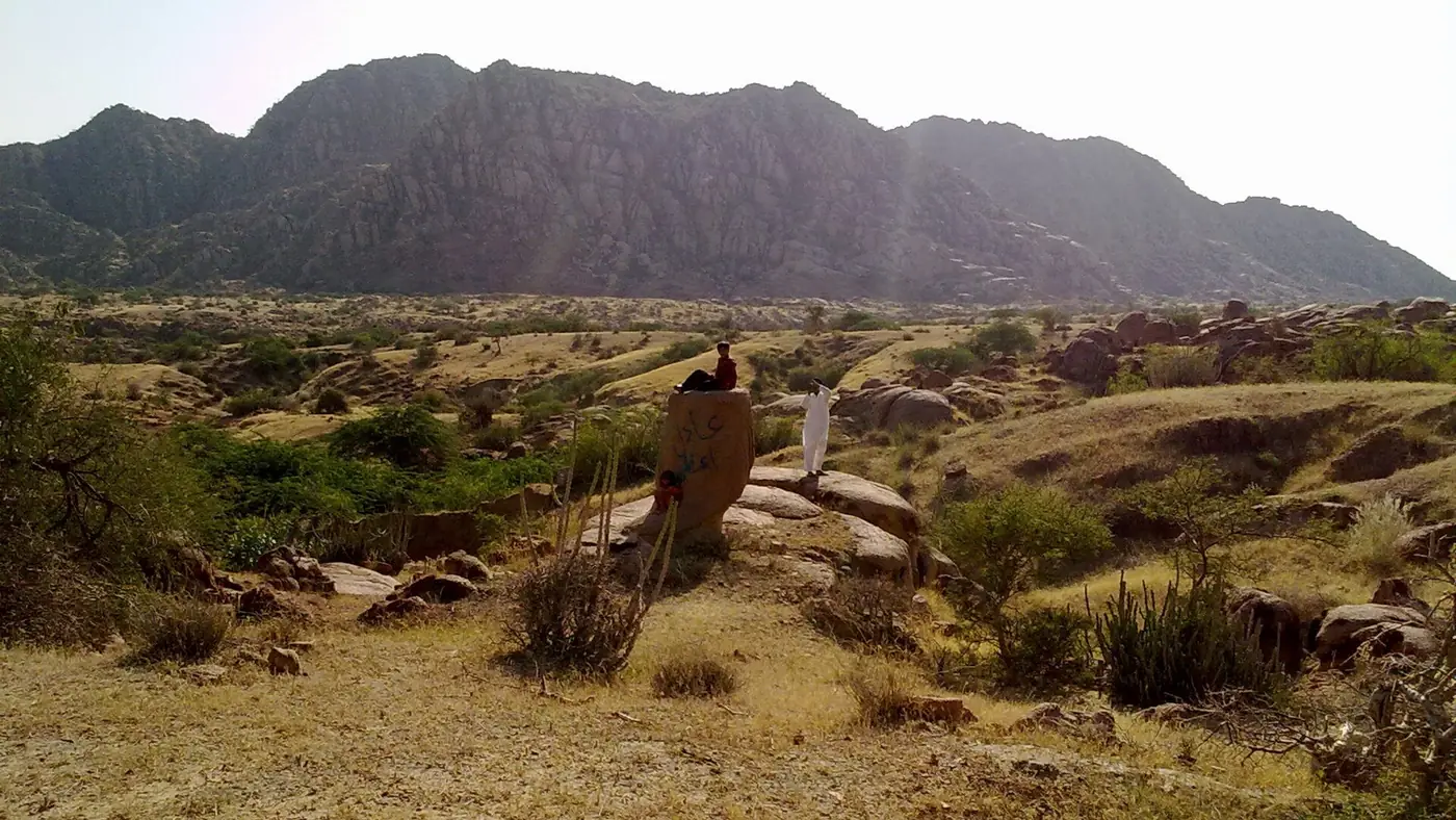
The Karoonjhar Mountains are a 19-km range of pink granite hills near Nagarparkar, in the far southeast of Sindh, and the most distinctive landscape in the Thar Desert. They rise abruptly out of flat desert to a modest 305 metres, but next to the surrounding dunes they feel like real mountains, cut through with seasonal streams that only run after rain.
This guide covers what there is to see and hike in the Karoonjhar hills, when the streams flow, and the mining dispute that shaped how the range is protected today.
| At a glance | |
|---|---|
| Length | About 19 km |
| Highest point | About 305 m above sea level |
| Rock | Pink granite, thought to be an extension of India's Aravalli Range |
| Location | Foot of Nagarparkar, southeast Sindh, near the India border |
| Protected status | Mining banned by Sindh High Court order; part of the Rann of Kutch Wildlife Sanctuary |
| Best time to hike | Early morning, November to February, or just after monsoon for the streams |
What the Karoonjhar hills are
Karoonjhar is a 19-km ridge of granite rising out of the desert near Nagarparkar, believed geologically to be an extension of India's Aravalli Range, which runs into Rajasthan on the other side of the border. At their highest point the hills reach only about 305 metres, which makes them one of the lowest ranges anywhere in Pakistan, but the contrast with the flat desert around them is what makes them stand out. The rock itself gives the hills their colour: a warm pink-grey granite that shows clearly at sunrise and sunset.
Beneath the surface the range holds significant deposits of granite and china clay, which is at the centre of why the hills are now protected rather than mined, covered below.
Streams, springs and monsoon colour
After rain, water runs off the Karoonjhar hills through more than twenty seasonal streams, with names including Bhatiani, Maoo and Gordaro among them. These only flow after rain and are dry for most of the year. Two springs on the eastern side of the range, Achleshwar and Sardharo, run year-round, and Sardharo has been developed by the Sindh Tourism Development Corporation as a picnic point, making it the easiest of the springs to visit without a long walk.
The hills are greenest and the streams most active in the weeks just after the monsoon, from around August into early autumn. Our guide to Tharparkar in monsoon covers that season and its trade-offs across the wider district.
Hiking in Karoonjhar
There is no formal trail network or marked route system in Karoonjhar, but the hills are low, dry underfoot outside monsoon, and popular with local hikers, who have worn informal footpaths across much of the range. Most visits are short, unguided walks rather than full-day treks: up from the base near Nagarparkar towards one of the ridgelines, or along one of the seasonal stream beds when they are dry.
A few things worth knowing before setting out:
- Go early. There is little shade on open granite, and even in the cooler months the sun is strong by mid-morning.
- Carry water. There is no reliable water source on the open hillside outside the two springs.
- Stick to visible paths and avoid wandering close to the border side of the range. The area is patrolled and unmarked ground close to the frontier is not the place to improvise a route.
- A local guide from Nagarparkar is worth arranging if you want to reach one of the streams or a specific viewpoint rather than just walking up and back.
Given the proximity to the India border, this is not a range to treat casually. Our guide to Nagarparkar covers the border-area rules and current security picture in more detail.
A hideout for resistance, not just a landscape
The Karoonjhar hills have a place in Sindh's history of resistance to British colonial rule. Rooplo Kolhi, a local fighter, used the range's terrain against British forces in the mid-19th century, before being captured and hanged in 1858 along with his companions. The government-run resort at the foot of the hills near Nagarparkar is named after him, and it is a reminder that the hills were once as much a refuge as a landmark.
Wildlife and plant life
Botanists have recorded 89 plant species across 26 families in the Karoonjhar hills, most of them grasses and low herbs rather than trees, which suits the thin soil on granite. Historically the range supported blackbuck, Indian gazelle and blue bull; today the Indian gazelle and desert hare are the species of most conservation interest, alongside the birdlife the hills share with the rest of Tharparkar.
The mining dispute and why the hills are protected
Karoonjhar's granite and china clay deposits made the range a target for commercial quarrying, and the resulting dispute became a genuine conservation fight. The Sindh High Court ordered a halt to mining and excavation across the range, and the entire Karoonjhar range is now designated a protected monument, falling within the Rann of Kutch Wildlife Sanctuary under Sindh's 2020 wildlife protection legislation. The result is a landscape that, unlike much of the rest of Tharparkar's mineral-rich ground, is not being actively quarried, though the underlying pressure to extract the deposits has not disappeared and local reporting continues to track it.
Best viewpoints and when to be there
The clearest views over the desert are from the higher points on the western side of the range, closest to Nagarparkar, reachable on a walk of an hour or so from the base. Early morning gives the best light on the pink granite and the coolest walking conditions; by late morning in the warmer months the open rock is uncomfortably hot underfoot and in the sun. Sunset is the other good window, though it means walking back down in fading light, so carry a torch if you plan to stay for it.
Is it worth the trip?
If you are already travelling to Nagarparkar for the Jain temples, the Karoonjhar hills are effectively part of the same visit and worth an early morning before or after the temples. As a destination on their own, from Karachi or even from Mithi, they are a long way to come for a range with no dramatic peak or marked trail, and the reward is more about the landscape and the walk itself than any single sight. Travellers who enjoy quiet, informal hiking in an unusual setting will get more from Karoonjhar than those looking for a defined attraction.
Frequently asked questions
How do you get to the Karoonjhar Mountains?
Through Nagarparkar, which sits at the foot of the range, about 150 km and three to three and a half hours from Mithi by road.
Is it safe to hike in the Karoonjhar hills?
The hills themselves present no unusual hazard beyond heat and lack of shade, but the range sits close to the India-Pakistan border and is patrolled by Rangers. Stick to visible paths, carry identification, and check current advice before travelling.
When do the Karoonjhar streams flow?
Only after monsoon rain, roughly July to September, with the strongest flow in the weeks that follow. The two perennial springs, Achleshwar and Sardharo, run year-round.
Can you mine or quarry in the Karoonjhar hills?
No. The Sindh High Court has ordered a halt to mining and excavation, and the range is now a protected monument within the Rann of Kutch Wildlife Sanctuary.
Do you need a guide to hike in Karoonjhar?
Not strictly, for a short walk on the well-used paths near Nagarparkar, but a local guide is worth arranging if you want to reach a specific stream or viewpoint, and is a sensible precaution given the border-area setting.