
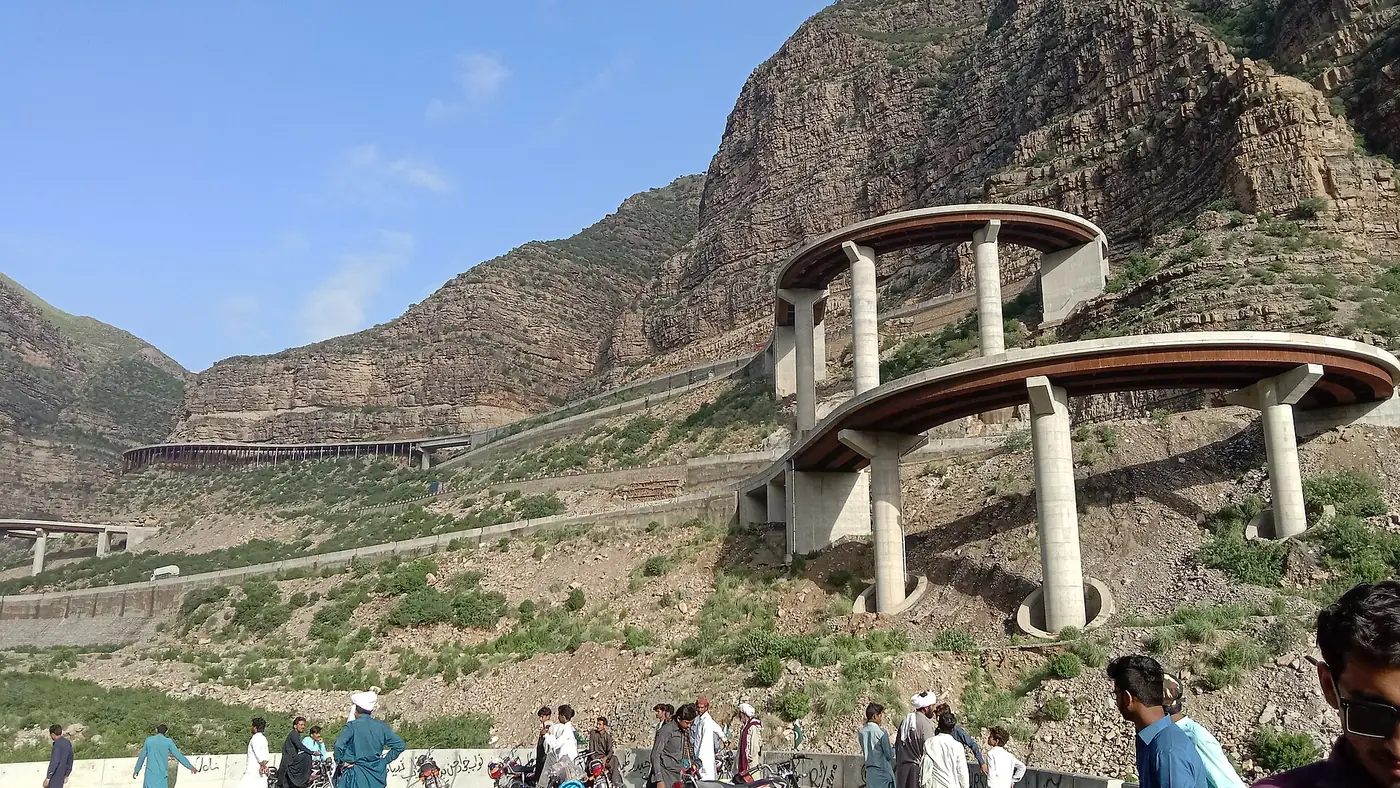

The way to reach Fort Munro is the N-70 national highway from Dera Ghazi Khan, a drive of about 85 km that takes around two hours in normal conditions. Coming from Multan, add the roughly 100 km to Dera Ghazi Khan first, for a total journey of about 185 km and three and a half to four hours. This guide covers the route in both directions, what public transport exists, and why the last stretch is not one to drive in the dark.
| At a glance | |
|---|---|
| From Dera Ghazi Khan | About 85 km on the N-70, around 2 hours |
| From Multan | About 185 km, around 3.5 to 4 hours |
| Road | Paved national highway (N-70) the whole way |
| Public transport | Limited; buses and coasters run from DG Khan bus stand toward Loralai via Fort Munro |
| Fuel | Fill up in Dera Ghazi Khan; don't count on stations on the climb |
| Best time of day | Daylight, ideally starting in the morning |
The route from Multan
Leaving Multan, the drive to Fort Munro runs south-west on the road network toward Dera Ghazi Khan, crossing the flat agricultural plain of South Punjab. This first stage is straightforward highway driving, roughly 100 km, and takes about an hour and a half to two hours depending on traffic through the towns along the way.
At Dera Ghazi Khan you join the N-70, which continues west and is the only road up to Fort Munro. Treat Dera Ghazi Khan as your last real town: fuel, food, a bank and phone signal are all easiest to sort out here before the climb starts.
The route from Dera Ghazi Khan
From Dera Ghazi Khan the N-70 heads west across the plain before meeting the wall of the Sulaiman range. The road passes near the town of Sakhi Sarwar, then begins to climb in earnest at Rakhi Gaj.
This is the section people mean when they talk about the Fort Munro road. For decades it was a genuinely difficult climb, with tight hairpin bends that slowed even light traffic to a crawl. Between 2016 and about 2019, the toughest stretch, from Rakhi Gaj over the Girdu pass, was rebuilt with financing from the Japan International Cooperation Agency (JICA). The project replaced the worst of the old hairpins with eight linked steel bridges, together around 1.5 km long, carrying the road across the steepest ground. The bridges are now a landmark in their own right, and most visitors slow down to look at them on the way through.
Past the bridges the road continues climbing to Fort Munro itself, still on paved national highway surface. In good conditions a normal car, including a sedan, can make the drive without difficulty.
How long to allow
Budget around two hours for the 85 km from Dera Ghazi Khan, more if you are behind heavy trucks or travelling on a public holiday when traffic is heavier. From Multan, allow three and a half to four hours door to door, including the stop in Dera Ghazi Khan. Add extra time on any day when snow has been reported, since traffic can back up for miles at Rakhi Gaj when large numbers of visitors head up at once.
Public transport
Public transport to Fort Munro exists but is limited. Buses, coasters and wagons that run between Dera Ghazi Khan and Loralai in Balochistan pass through Fort Munro and can be picked up at the Dera Ghazi Khan bus stand, but services are infrequent and schedules are not fixed in the way an intercity coach route would be. There is no dedicated public transport service running directly from Multan to Fort Munro; anyone travelling by bus needs to reach Dera Ghazi Khan first and continue from there.
For most visitors, especially families and anyone without a fixed departure time in mind, a private car, a hired car with driver, or your own vehicle is the practical choice. It also means you are not tied to a bus timetable on the way back down.
Fuel, food and phone signal
Dera Ghazi Khan is the last place to reliably fill up before the climb. There is no dependable fuel station on the mountain section of the N-70, so start the ascent with a full tank. The same applies to cash: carry enough for the trip, since ATMs become unreliable once you leave Dera Ghazi Khan, and phone signal is patchy for stretches of the climb.
Why not to drive it at night
The N-70 above Rakhi Gaj is a mountain road shared with heavy trucks and trailers heading to and from Balochistan, many of them climbing or descending slowly on the same bends you are navigating. In daylight this is manageable if you drive to the road rather than the speed limit; at night, with limited lighting and less warning of a truck ahead on a blind curve, the same road becomes considerably riskier.
The practical answer is simple: leave early enough from Multan or Dera Ghazi Khan to reach Fort Munro well before dark, and if you are coming back down the same day, don't linger so long that the descent happens after sunset. If your schedule doesn't allow that, an overnight stay in Fort Munro is the safer option; see our guide to where to stay in Fort Munro for what's available.
Driving tips for the climb
- Keep to your lane on the bends and never overtake on a blind curve, however slow the vehicle ahead is moving.
- Use low gears on the descent rather than riding the brakes the whole way down.
- Stop for photographs only at proper lay-bys, not on the bridges or on a bend.
- Check current road conditions before setting out in winter, since snow can close the top section without much notice.
- Carry your CNIC and expect to stop at checkposts along the way; follow whatever the police on duty ask.
For more on driving through South Punjab's hill country and planning a wider route, see our trip planning page and our travel guide.
Frequently asked questions
How far is Fort Munro from Multan?
About 185 km, made up of roughly 100 km from Multan to Dera Ghazi Khan and then about 85 km on the N-70 up to Fort Munro. Allow three and a half to four hours in total.
How long does the drive from Dera Ghazi Khan take?
Around two hours for the 85 km on the N-70, longer if you're behind heavy trucks on the climb or travelling on a busy weekend or public holiday.
Is there a bus to Fort Munro?
Buses and coasters running between Dera Ghazi Khan and Loralai pass through Fort Munro and can be caught from the Dera Ghazi Khan bus stand, but services are infrequent. There's no direct service from Multan.
Can a normal car make the drive to Fort Munro?
Yes. The N-70 is paved the whole way, including the rebuilt steel-bridge section near Rakhi Gaj, and a car in good condition can manage it comfortably in daylight.
Is it safe to drive to Fort Munro at night?
It's best avoided. The mountain section carries heavy truck traffic on tight bends with limited lighting. Time the trip to arrive, and ideally to descend, in daylight.
Where should I fill up before the climb?
In Dera Ghazi Khan. There's no reliable fuel station on the mountain stretch of the N-70 between there and Fort Munro.