Hingol National Park is a protected area of about 6,100 square kilometres on the Makran coast of Balochistan, roughly four hours' drive west of Karachi. Declared in 1988, it takes in desert, clay mountains, the Hingol River and a long stretch of Arabian Sea coast. For almost every visitor, the park is what lies along the Makran Coastal Highway: the Chandragup mud volcano, the Hingol River at Aghor, Kund Malir beach, and the eroded formations known as the Sphinx and the Princess of Hope. All of them can be seen in a long day from Karachi, and the best months are October to March.
This guide gives an overview of the park: what the landscape is, which sights sit along the road and in what order, what lives there, where you actually enter, and how to visit without leaving a mark.
| At a glance | |
|---|---|
| Area | About 6,100 km² |
| Declared | 1988 |
| Districts | Lasbela, Awaran and Gwadar, Balochistan |
| Managed by | Balochistan Forest & Wildlife Department |
| Access | Makran Coastal Highway (N-10), from Zero Point near Uthal |
| From Karachi | About 200 km to Chandragup, 240 km to Kund Malir |
| Best months | October to March |
| Facilities | Very few: huts and simple restaurants at Kund Malir; last reliable fuel at Zero Point |
Is Hingol Pakistan's largest national park?
Hingol is usually described as Pakistan's largest national park, and it is certainly huge: about 6,100 km², stretching from the coast far inland across three districts. On paper, though, Central Karakoram National Park in Gilgit-Baltistan covers more ground, at around 10,000 km². The fairer claim is that Hingol is by far the largest of Balochistan's three national parks and one of the largest protected areas in the country.
What sets it apart is less its size than its range. Few places in Pakistan put a sea coast, a river estuary, desert, mud volcanoes and bare mountain ranges into a single protected area.
What the landscape is like
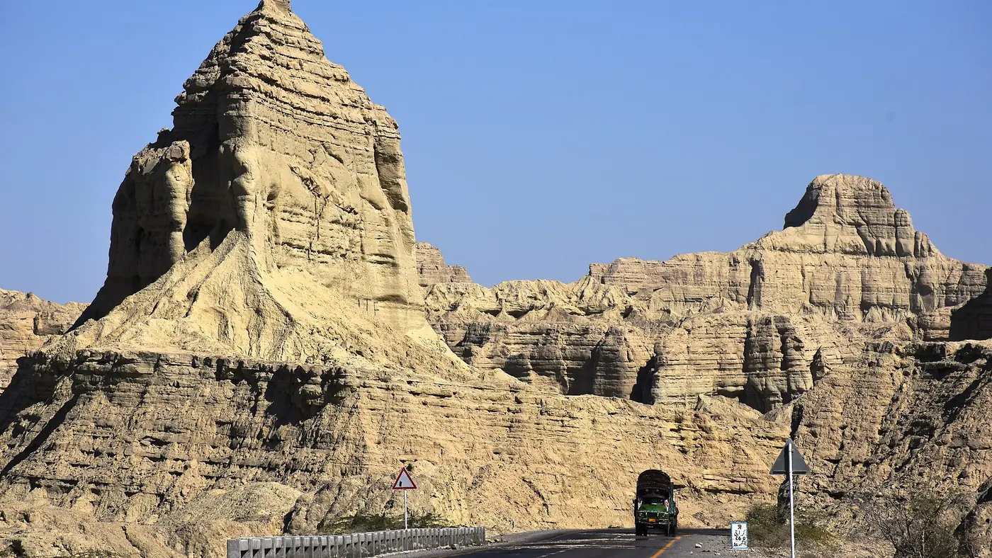
The drive into Hingol is a lesson in erosion. Much of the park is made of soft clay and silt, and wind and the occasional hard rain have carved it into ridges, pinnacles and fluted walls. The travel writer Salman Rashid described the hills around Buzi Pass as clay mountains that throw every kind of fantastic shape at the traveller, and that is exactly how it looks from the road.
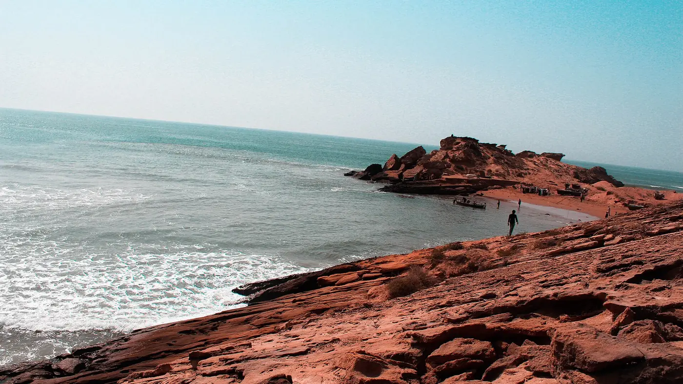
Inland, the north of the park is dry scrub forest and open plains. The Hingol River, the longest river in Balochistan at around 560 km, runs through the park all year and forms an estuary before it reaches the Arabian Sea. The coast itself has long sandy beaches, cliffs, caves and patches of mangrove, and after rain a shallow seasonal lake can appear near Sapat beach.
The colours change with the light. At midday the hills look flat and grey-brown; in the early morning and late afternoon, the shadows bring out every ridge.
Roadside sights, from east to west
Driving from Karachi, you meet the park's best-known places in this order. The distances are approximate, measured from central Karachi.
- Chandragup mud volcano, about 200 km. A cone of grey mud a short drive off the highway on a dirt track, one of a group of active mud volcanoes in the park. It is sacred to Hindu pilgrims, who visit it before going on to Hinglaj.
- The Hingol River at Aghor, about 225 km. The highway crosses the river on a long bridge at the small settlement of Aghor. This is the heart of the park's river country, and where the road to Hinglaj turns off.
- Hinglaj Mata temple, 15 km up the valley from Aghor. A cave shrine in a narrow side valley off the Hingol River, and one of the most important Hindu pilgrimage sites in the region. The annual yatra in spring drew around 300,000 pilgrims in April 2026.
- Kund Malir, about 240 km. A long, open beach where the highway comes down to the sea, and the main place in the park with huts and restaurants for visitors. Our Kund Malir beach guide covers it in full.
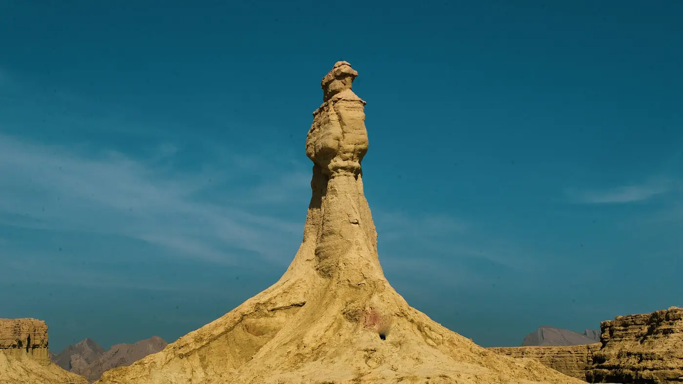
- The Sphinx and the Princess of Hope, about 265 km. Two eroded formations above the highway some 25 km west of Kund Malir. The Sphinx looks like a crouching lion with a human head; the Princess is a tall pinnacle shaped like a standing figure. See our guide to the Princess of Hope for where to stop.
- Buzi Pass, a few kilometres further. The highway climbs through the clay hills to a viewpoint over the coast, then drops towards Ormara.
Most day trips from Karachi cover Kund Malir and the Princess of Hope. Adding Chandragup or Hinglaj is easier on an overnight trip, because each adds an hour or more to a day that is already long. For timings and fuel on the way, see our guide to driving from Karachi to Kund Malir.
Wildlife: what lives in Hingol
Hingol's species list is long for a place that looks so bare. Around 35 species of mammal and 185 species of bird have been recorded in the park.
- Mountain animals. Sindh ibex live on the steep ridges, and urial on the lower hills. Chinkara, a small gazelle, use the plains inland.
- Predators. Leopards and caracals have been recorded, but they are rarely seen.
- Marsh crocodiles. The Hingol River supports one of Balochistan's few populations of mugger, or marsh crocodile, in its pools and estuary.
- Sea turtles. Green and olive ridley turtles use the park's coast, and dolphins live offshore.
- Birds. The estuary and coast attract migratory water birds in winter, including pelicans, and houbara bustards, falcons and vultures use the open country.
Be realistic about what you will see from the road. Most animals here are wary of people and keep to steep or remote ground. Your best chance is early in the morning or late in the afternoon, scanning the ridges with binoculars from a safe pull-off. Birds are easier, especially around the river and the coast in winter.
Where do you enter the park?
There is no single gate that every visitor passes. The Makran Coastal Highway runs through the southern part of the park for a long stretch, and in practice you enter where the road enters it, heading west from Zero Point or east from Ormara. From the highway, a handful of side roads and tracks lead to the places people visit:
- The Chandragup track, a short dirt road off the south side of the highway.
- The Hinglaj road from Aghor, which runs up the river valley to the temple.
- The Kund Malir turning, a short road from the highway down to the beach and village.
- Roadside stops at the Sphinx, the Princess of Hope and Buzi Pass, where you pull off the highway itself.
You will pass security checkposts on the highway, where you should expect to show your CNIC; foreign nationals face separate rules that change, so they should confirm the current position before travelling.
Entry fees for the park are not clearly published. If a fee is being collected when you visit, it should be at an official post and against a receipt. Rules on camping away from Kund Malir, going deep into the interior, and flying drones are set by the Balochistan Forest & Wildlife Department, so check with them rather than relying on what you read online. The park's interior, reached by tracks north of the highway, is remote, has no services, and is no place to go without a local guide and a 4x4.
Visiting responsibly
Hingol is protected because it is fragile, and the soft clay that makes it so striking is also easily damaged.
- Stay on roads and existing tracks. Tyre marks on clay flats and dunes last for years, and driving on beaches can destroy turtle nests.
- Don't climb on the formations. The Princess of Hope, the Sphinx and the pinnacles around them are compacted clay. Footholds break away and names scratched into them never go.
- Leave the wildlife alone. Hunting is not permitted in a national park. Don't chase animals for a photograph, and don't feed anything.
- Keep well back from the river's pools. Crocodiles live in them, and they are dangerous at close range.
- Take your rubbish home. There is almost no waste collection in the park, and litter blows straight into the gullies and onto the beach.
- Bring charcoal or a stove if you plan to cook. Wood is scarce in a desert, and the few trees and shrubs matter to the animals that live there.
- Respect Hinglaj and Chandragup as places of worship. Dress modestly, follow the instructions of the people who look after them, and ask before photographing pilgrims.
Planning a visit
October to March is the season. The days are warm, the nights are cool, and the sea at Kund Malir is at its calmest. From May to September the heat is severe, there is very little shade anywhere in the park, and the sea is rough.
A day trip from Karachi means leaving at dawn and turning back in the early afternoon, so that you drive home in daylight. An overnight at Kund Malir gives you the formations in the soft light of early morning and evening, and time for Chandragup or Hinglaj as well.
Carry more water than you think you need, sun protection and cash, and download offline maps before you go, since mobile signal is patchy across the park. The security situation in Balochistan has worsened since 2025, so check the news for incidents on N-25 and the coastal highway before you set off; our guide to safety at Kund Malir explains what to look for and when to postpone.
Who will enjoy Hingol, and who won't
Hingol rewards people who like landscape more than facilities. If you enjoy desert, geology, empty coast and long drives with the window down, it is one of the most striking places within reach of Karachi. It suits photographers, groups of friends, and families with older children who can handle a long day and heat.
It is harder going for anyone who needs shade, clean toilets and food on demand, for very young children, and for anyone with a health condition that makes being hours from a hospital a worry. There are no lodges, visitor centres or guided trails inside the park. If you would like help deciding whether Hingol fits your group, or how to combine it with other places, start with our trip planning page.
Frequently asked questions
Where is Hingol National Park?
On the Makran coast of Balochistan, in Lasbela, Awaran and Gwadar districts. The Makran Coastal Highway (N-10) runs through its southern part, about four hours' drive west of Karachi.
How far is Hingol National Park from Karachi?
The park's first well-known sight, the Chandragup mud volcano, is about 200 km from central Karachi, and Kund Malir beach about 240 km. Allow three and a half to four hours to reach the middle of the park.
Is there an entry fee for Hingol National Park?
No fee is clearly published. If one is collected when you visit, it should be at an official post with a receipt, so carry some cash in case.
What animals live in Hingol National Park?
Sindh ibex, urial, chinkara, marsh crocodiles, sea turtles and around 185 species of birds, with leopards and caracals recorded but rarely seen. From the road, birds and the occasional ibex are the most likely sightings.
Can you camp in Hingol National Park?
Many visitors camp on the beach at Kund Malir. Camping elsewhere in the park puts you far from help and phone signal, so check the current rules with the Balochistan Forest & Wildlife Department before planning it.
Is Hingol National Park worth visiting?
Yes, if you like desert, coast and geology and can handle a long, hot day. It is not a park with facilities, trails or guides on hand, so plan it as a road trip rather than a park visit.